Albuquerque grew rapidly after the railroad arrived in 1880, but the city's expansion into the Rio Grande valley and the surrounding mesas brought geotechnical challenges that are still relevant today. The contrast between the alluvial soils of the valley and the cemented caliche layers on the West Mesa means that a single boring often misses critical changes in resistivity. That's where electrical resistivity / VES surveys become essential. By measuring how different soil and rock layers resist electrical current, we can map the subsurface without disturbing the site. For deeper profiling in the valley fill, we often combine this method with MASW / Vs30 to capture shear wave velocity data alongside resistivity anomalies. The result is a more complete picture of Albuquerque's variable ground conditions, from the water table depth near the Rio Grande to the clay-rich zones beneath the eastern foothills.
A single resistivity profile in the Albuquerque West Mesa can reveal caliche cap, clay lenses, and water table depth in one non-invasive survey.
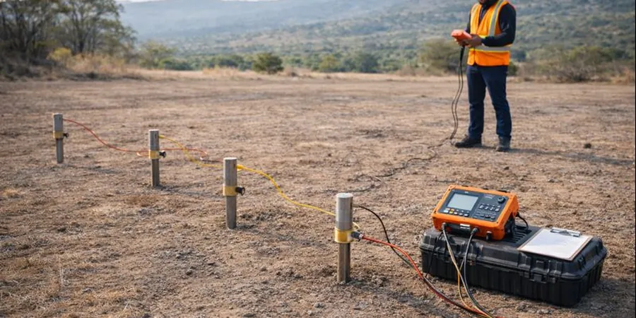
Methodology and scope
- Apparent resistivity (Ohm-m) for each electrode spacing
- Inverted true resistivity model using smooth inversion (Occam or L2 norm)
- Estimated depth to resistive or conductive layer boundaries
- Anisotropy index derived from orthogonal profiles
Local considerations
The geology near Albuquerque is dominated by the Santa Fe Group sediments, which are highly heterogeneous. In the eastern foothills, the alluvial fans contain cobbles and gravel that create sharp resistivity contrasts with the finer matrix. That can lead to misinterpretation if the inversion model is not constrained by at least one borehole. We always recommend at least one calibration boring when running electrical resistivity / VES in these areas. The water table in the Rio Grande valley sits at 6 to 12 meters deep, but the shallow clay layers can produce a false low-resistivity anomaly that mimics a higher water table. Without careful curve matching and layer boundary analysis, a project might overestimate the depth to groundwater. This risk is especially high in the South Valley, where the clay is both thick and electrically conductive.
Applicable standards
ASTM D6431-18 (Standard Guide for Using the Direct Current Resistivity Method), ASTM D5730-04 (Standard Guide for Site Characterization for Environmental Purposes), SEG 2015 (Society of Exploration Geophysicists – Resistivity and IP field procedures)
Associated technical services
Vertical Electrical Soundings (VES) for depth-to-bedrock mapping
Schlumberger and Wenner arrays with AB/2 spacing up to 150 m. We invert the data to produce a 1D resistivity-depth model that identifies the depth to competent bedrock or the water table. Common in the West Mesa and North Valley areas.
2D Resistivity Profiling for lateral anomaly detection
Multi-electrode (up to 96) profiles with 2–5 m electrode spacing. Ideal for detecting buried channels, abandoned landfills, or clay-filled paleochannels. We process the data with RES2DINV to generate a continuous resistivity section.
Time-lapse Resistivity for monitoring groundwater changes
Repeat surveys over weeks or months to track water table fluctuations or contaminant plume movement. Used in environmental site assessments near the Rio Grande and in industrial areas of South Albuquerque.
Typical parameters
Frequently asked questions
How is electrical resistivity / VES used in Albuquerque's alluvial soils?
In the Rio Grande valley, the alluvial soils are a mix of sand, silt, clay, and gravel. A VES survey maps the resistivity contrast between these layers, which correlates with grain size and water content. We typically see resistivity values from 10 Ohm-m in saturated clay to over 500 Ohm-m in dry gravel. The method is especially useful for estimating the depth to the water table and identifying clay lenses that could affect foundation design.
What is the typical cost range for a resistivity / VES survey in Albuquerque?
For a standard VES survey with 10 to 20 soundings and data inversion, the cost ranges from US$680 to US$1,100. The final price depends on the number of soundings, the depth of investigation, and whether a 2D profile is required. We provide a detailed quote after reviewing the site area and the expected depth range.
Can electrical resistivity detect the caliche layer on the West Mesa?
Yes, caliche has a very high resistivity (often above 200 Ohm-m) compared to the underlying sandy clay (10–50 Ohm-m). A VES with a Schlumberger array can clearly identify the caliche cap and estimate its thickness. This is critical for designing shallow foundations or utility trenches, since caliche can be difficult to excavate but also provides high bearing capacity.
How deep can a VES survey go in the Albuquerque area?
With a maximum AB/2 spacing of 150 meters, the depth of investigation is typically between 50 and 60 meters. In the valley, where low-resistivity clays are present, the effective depth may be slightly less due to current channeling. For deeper targets, we recommend combining VES with a seismic refraction survey or a MASW array to extend the depth range.