Albuquerque's expansion from a historic crossroads along the Camino Real into a sprawling high-desert metropolis has placed increasing demands on geotechnical site characterization, particularly where the subsurface hides abrupt transitions between coarse alluvial fans and fine-grained playa deposits. The Rio Grande rift defines much of the structural setting: unconsolidated Santa Fe Group sediments reach thicknesses of over 4,000 meters in the basin, creating a depositional environment where grain size and cementation can shift dramatically within a single construction site. Electrical resistivity surveying, and specifically Vertical Electrical Sounding, provides a non-invasive way to map these vertical and lateral stratigraphic contrasts before a single borehole is advanced. Because the method responds to changes in pore-water salinity and clay content — both common in the central basin — it often reveals buried channel sands or perched water zones that conventional drilling alone might misrepresent. In our experience, integrating resistivity data early in the investigation program across Albuquerque reduces the number of exploratory borings needed while sharpening the geological model that guides foundation design in this tectonically active valley.
In Albuquerque's basin-fill environment, a resistivity sounding often sees the water table as a sharp conductivity increase before a drill bit ever touches saturated soil.
Process and scope
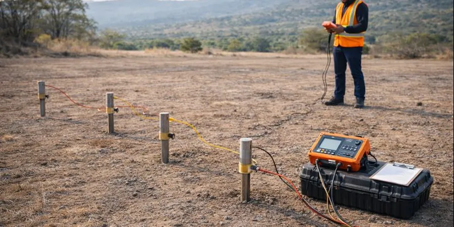
- Electrode arrays configured in Wenner and Schlumberger geometries to balance vertical resolution and signal strength.
- Interpretation software that performs smooth-model inversion and layered-earth modeling with topographic correction.
- Field acquisition designed to avoid buried utilities and reinforced concrete, which can distort current paths in the urban corridor.
Area-specific notes
Albuquerque sits within the Rio Grande rift, a region of moderate seismicity where basin-edge faults and intrabasin fractures can compartmentalize groundwater and create abrupt lateral changes in soil stiffness. A resistivity line run across a proposed building pad near the Sandia foothills, for example, may detect a steeply dipping conductive zone that corresponds to a clay-filled fault gouge — a feature critical to foundation continuity but invisible to widely spaced borings. The city's semi-arid climate also means that near-surface moisture content fluctuates seasonally, which can shift apparent resistivity values by 15 to 25 percent between a dry June and a monsoon-fed August; scheduling surveys during consistent moisture conditions and calibrating soundings against at least one logged borehole are practices we have found essential for reliable interpretation. Ignoring these lateral heterogeneities risks designing foundations that encounter unexpected differential settlement when clay lenses swell with irrigation water or when pumping-induced subsidence reactivates buried scarps.
Relevant standards
ASTM D6431-18 Standard Guide for Using the Direct Current Resistivity Method for Subsurface Investigation, ASCE 7-22 Minimum Design Loads and Associated Criteria for Buildings and Other Structures (seismic site class determination), IBC 2021 Chapter 18 Soils and Foundations (supplemental geophysical investigation provisions), USACE EM 1110-1-1802 Geophysical Exploration for Engineering and Environmental Investigations, AASHTO R 27-01 (2019) Standard Practice for Assessment of Corrosion of Steel Piling Using Resistivity
Linked services
Vertical Electrical Sounding (VES) for Foundation Depth
A one-dimensional resistivity depth profile acquired at a single point using expanding electrode spacing. Ideal for estimating depth to competent bearing strata such as the Santa Fe Group gravels and for identifying the saturated zone beneath proposed spread footings or mat foundations in Albuquerque's valley fill.
2D Electrical Resistivity Tomography (ERT) Profiles
A multi-electrode cable laid along a transect to produce a continuous cross-section of resistivity distribution. We recommend this configuration for pipeline corridors, roadway alignments, and sites near the Sandia fault zone where lateral changes in lithology or moisture must be traced over tens to hundreds of meters.
Corrosion Risk and Soil Aggressivity Assessment
Soil resistivity measured in-situ and on recovered samples to evaluate the corrosion potential for buried steel and ductile iron utilities. This service follows AASHTO R 27 guidelines and is frequently requested for infrastructure projects in Albuquerque's older neighborhoods where clay-rich soils retain moisture and elevate electrochemical activity.
Typical parameters
Common questions
How deep can a vertical electrical sounding investigate in Albuquerque's basin sediments?
With a maximum current-electrode spread of 200 meters, a VES can typically resolve layer boundaries to about 80–100 meters depth in the unconsolidated Santa Fe Group sediments that underlie Albuquerque. The actual depth of investigation depends on the resistivity contrast between layers: a conductive clay horizon at 60 meters will attenuate current penetration more than a resistive gravel, so we adjust the maximum spread length in the field based on real-time apparent resistivity curves. For deeper targets — such as mapping the basin-floor bedrock contact east of the Sandia fault — we may extend the spread or supplement VES with a seismic refraction line to confirm the velocity boundary.
Can electrical resistivity distinguish between dry gravel and cemented conglomerate?
Yes, and this distinction is particularly relevant in Albuquerque where the upper Santa Fe Formation contains both uncemented channel gravels and calcite-cemented conglomerate lenses. Dry, clean gravel typically exhibits resistivity values above 300 ohm-m, while well-cemented conglomerate — even when dry — often reads somewhat lower, in the 150–250 ohm-m range, because the cementing minerals themselves contribute to surface conduction. We calibrate these thresholds by comparing at least one resistivity sounding with a nearby borehole log or test pit where the degree of cementation can be observed directly, which then allows us to extrapolate the cemented zones across the rest of the resistivity profile.
What does a typical electrical resistivity survey cost for a residential lot in Albuquerque?
For a standard residential lot investigation — typically two to three VES soundings with a maximum spread of 100 meters each, or a single 2D resistivity line of equivalent coverage — the cost ranges from US$680 to US$1,100. The final price depends on site accessibility, the presence of buried utilities that require careful electrode placement, and whether we need to mobilize additional equipment for hard caliche surfaces common on Albuquerque's West Mesa. This fee includes field acquisition, data processing, layered-earth inversion, and a signed report with interpreted depth sections.
How does seasonal moisture affect resistivity readings in Albuquerque's semi-arid climate?
Seasonal variation is a factor we account for in every Albuquerque survey. During the dry months of April through June, the upper 2 to 3 meters of soil can desiccate to the point where resistivity values increase by 20–30 percent compared to the same profile measured after the monsoon rains of July and August. We mitigate this by recording soil moisture conditions at the time of the survey, by scheduling comparative soundings during the same seasonal window when monitoring a site over time, and by normalizing interpreted resistivities against a saturated reference measurement when evaluating long-term corrosion potential or foundation drainage requirements. More info.