A six-story mixed-use project off Central Avenue got flagged by the city reviewer in 2022 because the geotech report didn't address liquefaction potential in the shallow sands beneath the old commercial strip. Albuquerque sits on the active Rio Grande Rift, and while we don't get the 7.0 events that hit the coast, the basin fill—loose Holocene alluvium, silty sands, and interbedded clays—can lose bearing capacity under moderate shaking from faults like the Sandia or Rincon systems. We got pulled in to run SPT-based triggering analysis per the updated NCEER/Youd-Idriss framework and a site-specific PGA from the USGS hazard tool. That's what our soil liquefaction analysis delivers: not a generic checkbox, but a defensible assessment tied to the actual stratigraphy under your site. SPT drilling gives us the raw N-values, and when we need a finer profile through interlayered silts, we pair it with CPT testing to catch thin seams the spoon misses. The goal is simple: know whether your ground will hold when it matters.
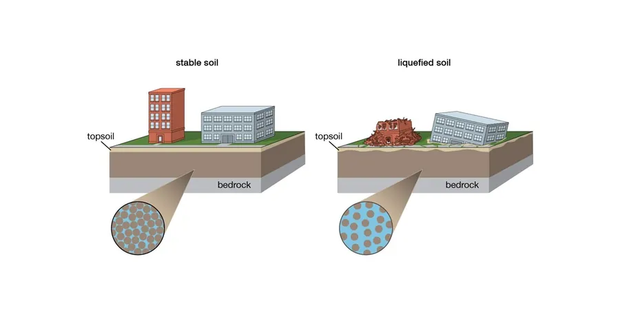
Liquefaction isn't just a coastal problem—loose saturated sands in the Rio Grande basin can fluidize under PGA values as low as 0.15g, turning solid ground into a slurry in seconds.
Process and scope
Area-specific notes
The most common mistake we see on Albuquerque projects—especially on infill lots in older neighborhoods—is treating alluvial sands as competent bearing soils just because the blow counts look decent in the upper five feet. You get N-values of 12 to 18 and the drill log says 'medium dense sand,' so the structural engineer runs with a 2,500 psf bearing capacity and moves on. The problem: that same sand at eight to fifteen feet, below the water table, with over 30% fines, can trigger liquefaction at a CSR below 0.25. We've seen projects where the foundation design had to be completely reworked—going from shallow footings to driven piles or ground improvement—because the original report didn't run a site-specific liquefaction screen. When the IBC Chapter 18 triggers a seismic site class F for liquefiable soils, the cost impact is real. Getting the analysis right before the structural drawings are locked saves months of redesign and keeps the project on schedule.
Relevant standards
ASTM D1586-18: Standard Test Method for SPT and Split-Barrel Sampling, NCEER/NSF Workshop on Evaluation of Liquefaction Resistance (Youd & Idriss 2001), IBC 2021 Section 1803: Geotechnical Investigations, Seismic Site Classification, ASTM D2487-17: Unified Soil Classification System for Lab and Field Identification
Linked services
SPT-based liquefaction triggering with lab confirmation
We drill to a minimum depth of 50 feet or refusal, recovering split-spoon samples every 2.5 feet through potentially liquefiable strata. Each sample goes to our lab for grain-size distribution and Atterberg limits, so the CRR correction for fines content is based on actual soil behavior, not assumed values. We run the numbers through the simplified procedure with site-specific PGA and magnitude deaggregation, delivering a factor-of-safety profile that tells the structural engineer exactly which layers need mitigation.
Post-liquefaction settlement and lateral spread assessment
For sites within a mile of the Rio Grande or adjacent to arroyo channels, we evaluate free-field settlement using the Ishihara and Yoshimine volumetric strain method, calibrated to the corrected SPT data. This gives the project team a realistic range of vertical displacement—typically 0.5 to 4 inches in our basin sands—and identifies zones where lateral spreading toward a free face could compromise buried utilities or deep foundations. The output integrates directly into the foundation design parameters and any required ground improvement scope.
Typical parameters
Common questions
Does Albuquerque actually have a liquefaction risk, or is this only a California concern?
It's a fair question, and the short answer is yes—Albuquerque has a real but localized liquefaction hazard. The city lies within the Rio Grande Rift, a seismically active extensional basin with mapped Quaternary faults capable of generating magnitude 6.0 to 7.0 events. Liquefaction susceptibility maps from the New Mexico Bureau of Geology show moderate-to-high potential along the Rio Grande floodplain and in areas with shallow groundwater. The USGS seismic hazard model assigns a PGA of 0.12g to 0.18g for much of the metro area at the 2%-in-50-year level, which is enough to trigger liquefaction in loose, saturated sands. Whether your specific site is at risk depends on depth to water, soil gradation, and relative density—all things a proper subsurface investigation can nail down.
What does a soil liquefaction analysis typically cost for a commercial building site in Albuquerque?
For a standard commercial lot requiring two to three boreholes to 50 feet with SPT sampling and full lab characterization (grain size and Atterberg limits on selected samples), plus the engineering analysis and report, the range generally falls between US$2,660 and US$4,760. The spread depends on access constraints, depth to groundwater, and whether we need a CPT rig for supplemental profiling. If the analysis reveals a need for ground improvement design or post-liquefaction settlement calculations, that adds to the scope but keeps the foundation design grounded in real data rather than conservative assumptions.
What lab tests do you run to support liquefaction triggering curves?
We run grain-size distribution per ASTM D6913/D1140 on every sample from potentially liquefiable layers, because the fines content correction in the NCEER procedure is sensitive at thresholds of 5%, 15%, and 35% passing the #200 sieve. We also determine Atterberg limits per ASTM D4318 to confirm whether fine-grained soils exhibit clay-like or sand-like cyclic behavior—a critical distinction that changes the entire analysis framework. For high-value projects where the factor of safety is borderline, we can run cyclic triaxial tests per ASTM D5311 to measure the actual CRR of undisturbed samples, though this is typically reserved for large infrastructure or when SPT-based correlations give ambiguous results.